Mana Village Uttarakhand – India’s First Village, History, Mythology & Travel Guide
The road ends at Mana. National Highway 7 terminates here — the northern terminus of a route that begins somewhere in peninsular India and stops at the last settlement before the Mana Pass, the Tibetan plateau, and the China border. For decades, a signboard at the village entrance read “India’s Last Village.” In 2022, the government quietly turned the sign around: Mana is now officially India’s First Village — the first inhabited settlement inside India when approaching from the Tibet direction. The reversal carries genuine symbolic weight. From a fringe to a frontier. The village at 3,200 metres above sea level, on the banks of the Saraswati River, with approximately 600 residents of the Bhotia (Marchha) tribe and a mythology so thick every rock has a Mahabharata story attached — has always been the same place. Only the framing changed.
Mana Village Uttarakhand – Quick Overview Table
| Detail | Information |
| Location | Chamoli District, Uttarakhand, India |
| Altitude | 3,200 metres (10,500 feet) above sea level |
| Distance from Badrinath | Approximately 3–5.5 km |
| District | Chamoli |
| State | Uttarakhand |
| Population (2011 Census) | 1,214; approximately 600 active residents; ~180 households |
| Community | Bhotia tribe — Marchha/Jad subtribes; Indo-Mongolian |
| Native Language | Rongpo (Marcha dialect); Hindi for outsider communication |
| Official Status | “India’s First Village” (formally renamed by Indian government, 2022) |
| Earlier Designation | “India’s Last Village” (last inhabited village on India-China border) |
| Highway | Northern terminus of National Highway 7 |
| River | Banks of River Saraswati (originates near the village) |
| Religious Confluence | Keshav Prayag — Saraswati meets Alaknanda |
| Season | Open May–early November; closed in winter due to heavy snow |
| Nearest Airport | Jolly Grant Airport, Dehradun (~318–327 km) |
| Nearest Railway Stations | Rishikesh (~295–300 km); Haridwar (~275–320 km) |
| Key Mythological Sites | Vyas Gufa; Ganesh Gufa; Bheem Pul; Mata Murti Temple |
| Key Treks | Mana to Vasudhara Falls; Mana to Satopanth Lake; Mana to Mana Pass |
| Famous For | Last/First village of India; Mahabharata caves; Saraswati River source; wool handicrafts |
History and the Bhotia Community
Mana village is inhabited by the Bhotia community — specifically the Marchha and Jad subtribes, classified as Bhotias under British colonial administrative categories. The Bhotias are Indo-Mongolian in origin, their physical features and cultural practices reflecting the trans-Himalayan influence of centuries of trade and cultural exchange across the Mana Pass with Tibet. They are described as the community of the high Himalaya — spending summers at altitude tending to pilgrims, running small shops, weaving wool, and maintaining the village, and descending to lower altitudes when snow closes Mana in winter.
Their livelihood has historically combined trans-border trade (before the 1962 India-China war closed the Mana Pass indefinitely), animal husbandry, and increasingly tourism services supporting the Badrinath pilgrim route. The Bhotia villagers maintain a deep cultural connection to Badrinath Temple — performing the annual traditional act of offering a choli (a garment) to the deity on the closing day of the temple each year, a ritual that demonstrates a ceremonial responsibility for the region’s most sacred site.
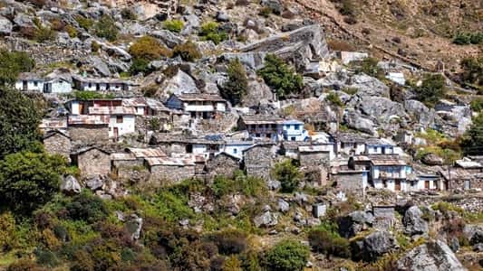
The village’s architecture is distinctive and immediately recognisable: small wooden cottages intricately carved and decorated, with colourful prayer flags adding Tibetan Buddhist visual elements alongside Hindu temples and shrines. The cultural identity is genuinely hybrid — Hindu pilgrim destination and Tibetan border community simultaneously.
Mythology — The Mahabharata Village
No aspect of Mana village can be discussed without the Mahabharata. Every physical feature of the village and its immediate surroundings carries a mythological attribution.
Vyas Gufa — A cave where Maharshi Vedvyas (Vyas) is believed to have composed the Mahabharata. The attribution is foundational to the village’s religious identity.
Ganesh Gufa — Adjacent to Vyas Gufa, this cave is where Lord Ganesha is said to have written the Mahabharata as Vyas dictated it. The two caves together represent the composition and transcription of the epic.
Bheem Pul — The most dramatic physical feature of the village. A massive natural stone slab bridges the roaring Saraswati River at a narrow gorge. Legend holds that Bheem — the strongest of the Pandava brothers — threw this boulder across the river so Draupadi could cross during the Pandavas’ final journey to heaven. The Saraswati River at Bheem Pul is extraordinarily loud and forceful, compressed through a narrow canyon before rushing beneath the boulder.
Keshav Prayag — The sacred confluence where the Saraswati River meets the Alaknanda, visible from the village. Prayagas (river confluences) are among the most sacred sites in the Ganga river system; Keshav Prayag is the only place where the Saraswati — a river that is described in the Vedas as disappearing underground — can be seen above ground.
Vasudhara Falls — Approximately 8 km from Mana village (2.8 km by road, then trekking), this frothy waterfall is believed to be a temporary stay point of the Pandavas during their exile. The water drops approximately 400 feet down a sheer cliff face into the valley below.
How to Reach Mana Village
By Air: Jolly Grant Airport in Dehradun is the nearest airport at approximately 318–327 km. From Dehradun, taxis or buses reach Joshimath and then Badrinath, with Mana being 3 km beyond.
By Train: Rishikesh (295–300 km) and Haridwar (275–320 km) are the nearest major railway stations. From either, taxis and Uttarakhand roadways buses travel to Joshimath and Badrinath.
By Road: The standard route follows NH-7 through Devprayag, Rudraprayag, Karnaprayag, Chamoli, Joshimath, and Badrinath before reaching Mana. The road through Joshimath involves mountain driving on narrow Himalayan roads with significant drop-offs. Drivers experienced with hill roads are strongly recommended for private vehicles.
Treks from Mana Village
Mana to Vasudhara Falls (2 hours) — The most popular day trek from the village, offering views of the Vasudhara River valley during an inclined approach. The falls are located 9 km from Badrinath Temple.
Mana to Satopanth Lake — A challenging multi-day high-altitude trek from Mana to Satopanth Tal, a glacial lake at approximately 4,400 metres. The lake is considered sacred and is said to hold special significance on the occasion of the Satopanth pilgrimage.
Mana to Mana Pass — The most demanding route, leading to the Mana Pass on the India-Tibet border. Permissions and guidance are required; this is a restricted zone.
5 FAQs About Mana Village Uttarakhand
Q1. Why is Mana village called India’s First Village?
Mana was formerly called India’s Last Village — the final inhabited settlement before the India-Tibet border. In 2022, the Indian government formally redesignated it as India’s First Village, to reflect its position as the first settlement when approaching from the Tibet direction. Both designations refer to the same geographic fact: Mana is the last/first permanently inhabited village before the international border.
Q2. How far is Mana village from Badrinath?
Approximately 3–5.5 km from Badrinath temple and bus stand, depending on the specific entry point. Most pilgrims completing their Badrinath darshan extend their visit by a short taxi or walking distance to Mana.
Q3. What is the Bheem Pul in Mana village?
A massive natural stone slab bridging the Saraswati River at a narrow gorge. Legend holds that Bheem, one of the Pandava brothers, placed this boulder across the river for Draupadi to cross during their final journey to heaven. The compressed river beneath it is exceptionally forceful and loud.
Q4. What is the best time to visit Mana village?
May to early November, with May-June being the peak season. The village is inaccessible in winter (November–April) due to heavy snowfall. Monsoon visits (July–August) require checking road conditions — landslides are a regular risk on the Badrinath highway.
Q5. Who are the Bhotia people of Mana village?
The Bhotias — specifically the Marchha and Jad subtribes — are Mana’s indigenous community of Indo-Mongolian origin. They spend summers in the village serving pilgrims and running small shops, and descend to lower altitudes in winter when snow closes the village. Their livelihoods include tourism services, wool weaving (woollen garments, shawls, carpets), animal husbandry, and their ceremonial role at Badrinath Temple.