Lampur Village Delhi – Location, History, Connectivity, Nearby Places & Complete Guide
Delhi’s northernmost inhabited belt — the zone between Narela’s industrial areas and the Sonipat district boundary of Haryana — consists of a chain of agricultural villages that mark the literal edge of the capital territory. Lampur is one of the outermost of these. In the Narela zone of North Delhi, close enough to the Haryana border that locals refer to it as “Lampur Border,” this quiet village carries two pin codes (110040 for the main village, 110039 for its sub-locality), sits adjacent to Sanoth and near the cluster of Narela-belt settlements including Holambi Kalan, Khera Khurd, Nangal Thakran, and Singhola. Its position — far from Delhi’s metro network, close to Narela Railway Station, and in the northernmost arc of the Narela constituency — gives it the character of a village that is unambiguously Delhi but exists at the quiet margin where the capital runs out of city.
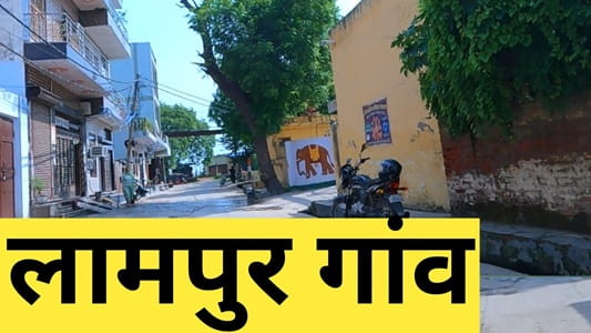
Lampur Village Delhi – Quick Overview Table
| Detail | Information |
| Location | Narela Zone, North Delhi District, Delhi |
| Also Known As | Lampur Border (proximity to Haryana-Sonipat boundary) |
| Pin Code | 110040 (main village); 110039 (Lampur sub-locality) |
| District | North Delhi |
| Zone | Narela Zone |
| Assembly Constituency | Narela |
| Assembly MLA | Sharad Chauhan |
| Lok Sabha Constituency | North West Delhi |
| Parliament MP | Hans Raj Hans |
| Safety Rating | 3.6/5 (99acres) |
| Post Office | Narela area |
| Nearest Railways | Narela Railway Station; Holambi Kalan Railway Station (Delhi-Chandigarh line) |
| Nearest Hospital | Shanti Mohan Hospital (~3 km); Sushila Hospital (~4 km) |
| Key Neighbouring Areas | Sanoth; Bawana; Holambi Kalan; Nangal Thakran; Singhola; Singhu; Holambi Khurd; Hamidpur Village; Khera Khurd; Bakoli; Alipur |
| Border Status | Close to Sonipat district, Haryana — referred to locally as Lampur Border |
| Plot Availability | Below ₹10 lakh and ₹10–₹20 lakh segments (99acres data) |
History and Border Character
Lampur sits at the place where Delhi ends. The Sonipat district boundary of Haryana is close enough that the village has acquired the informal suffix “Border” — Lampur Border — in local usage, distinguishing it from Lampur proper and indicating its position as one of Delhi’s last habitations before the administrative boundary transitions to Haryana.
The village is part of Delhi’s Narela Zone — the northernmost administrative division of the capital territory, which includes Narela town, Bawana industrial area, and a cluster of agricultural villages. The zone has historically been the one part of Delhi that most resembled the agricultural plains of Haryana and western UP: flatter, less urbanised, and economically connected to the farming belts of both states rather than to Delhi’s service economy. Lampur shares this character fully.
The name “Lampur” follows the north Indian village naming convention where “pur” means settlement — “Lam” possibly deriving from a founder’s name or a descriptive geographical term in the local dialect. Community and land records in the Narela zone contain the village’s documented history, but unlike the Narela-area villages with well-documented community literacy achievements (like Sanoth, whose educational records are preserved by the Hamdard family), Lampur’s recorded community history is less detailed in publicly available sources.
What defines Lampur practically is its adjacency: to Sanoth (pin 110040, same pin code belt), to the Narela industrial development zone, and to the Delhi-Chandigarh railway line whose Narela and Holambi Kalan stations are the village’s primary rail connections.
Connectivity
By Rail: Narela Railway Station and Holambi Kalan Railway Station, both on the Delhi-Chandigarh suburban line, are the nearest rail connections — approximately 4–6 km from Lampur. These stations connect southward toward New Delhi Railway Station via the suburban network and northward toward Panipat and Chandigarh.
By Road: The village is accessible via the road network linking Narela, Bawana, and the northern Delhi arterials. NH-9 and NH-248A — the national highways accessible to the broader Narela zone — provide the main road corridors.
By Metro: The nearest metro station is approximately 8–10 km away from Lampur — comparable to Khera Kalan and Sanoth’s metro distance. DTC buses connecting through Narela and Bawana are the primary public transport for daily commuters.
Key Landmarks and Nearby Places
Narela (~4–5 km) — The nearest town providing commercial markets, administrative offices, government services, banking, and Narela Railway Station access.
Bawana Industrial Area (~8–10 km) — Delhi’s largest planned industrial zone, the primary employment destination for workers from the Narela-belt villages including Lampur.
Singhu Border — The Singhu border crossing between Delhi and Haryana (on NH-44) is within the broader northern belt’s geography, a landmark familiar to anyone following the 2020-21 farmers’ protest that occupied this border for over a year. Lampur is in the same general north Delhi border zone.
Shanti Mohan Hospital (~3 km) and Sushila Hospital (~4 km) — The nearest healthcare facilities serving Lampur residents.
Sanoth Village (adjacent) — The neighbouring village sharing the same pin code belt and Narela constituency, with its documented community history and two railway station connectivity options.
5 FAQs About Lampur Village Delhi
Q1. What is Lampur village Delhi known for?
Lampur is a North Delhi village in the Narela Zone, close to the Haryana-Sonipat district boundary — locally called “Lampur Border.” It falls under the Narela assembly constituency (MLA: Sharad Chauhan), North West Delhi Lok Sabha (MP: Hans Raj Hans). Pin codes: 110040 (main) and 110039 (sub-locality).
Q2. Why is Lampur called “Lampur Border”?
Because the village sits close to the administrative boundary between Delhi’s North Delhi district and Sonipat district of Haryana — making it one of Delhi’s northernmost habitations before the border. The “Border” suffix distinguishes it in local usage from Lampur proper.
Q3. Which are the nearest railway stations to Lampur village Delhi?
Narela Railway Station and Holambi Kalan Railway Station, both on the Delhi-Chandigarh suburban line, are the nearest at approximately 4–6 km. These provide southward connectivity toward New Delhi Railway Station.
Q4. What is the assembly constituency for Lampur village Delhi?
Narela assembly constituency (MLA: Sharad Chauhan). Lok Sabha: North West Delhi constituency (MP: Hans Raj Hans). The village is part of the Narela Zone — Delhi’s northernmost administrative division.
Q5. What are the nearest hospitals to Lampur village Delhi?
Shanti Mohan Hospital at approximately 3 km and Sushila Hospital at approximately 4 km are the nearest healthcare facilities. For major specialist care, residents access hospitals in Narela town or the broader North Delhi zone.