Khanpur Village Delhi – Location, History, Connectivity, Nearby Places & Complete Guide
South Delhi’s urban village belt — Khanpur, Sangam Vihar, Deoli, Madangir — shares a character that the more discussed parts of the district don’t quite have. These are old settlements that grew into dense residential localities while remaining administratively villages, their Lal Dora land giving them a different property and governance texture from the DDA colonies and planned sectors that surround them. Khanpur sits in this belt, its name believed to trace back to the Mughal era and the Khanzada noble families who settled here, its MB Road frontage giving it the connectivity premium that most localities in this zone share.
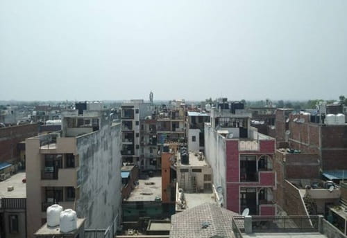
Khanpur Village Delhi – Quick Overview
| Detail | Information |
| Location | South Delhi District, Delhi |
| Pin Code | 110062 |
| Assembly Constituency | Deoli |
| Lok Sabha Constituency | South Delhi |
| Nearest Metro Station | Saket Metro Station – Yellow Line; approx. 3 km |
| Alternative Metro | Chirag Delhi Metro Station – Pink Line (Magenta Line); approx. 3–5 km |
| Primary Road Access | Mehrauli-Badarpur Road (MB Road); Sangam Vihar Road; Ignou Road |
| Key Nearby Areas | Sainik Farm; Pushp Vihar; Sangam Vihar; Saket; Alaknanda; Madangir |
| IGI Airport Distance | Approx. 16–18 km |
| Property Rate (2025) | ₹4,500 per sq ft (village average); Saket-adjacent zones significantly higher |
| Monthly Rent (2 BHK) | ₹8,800–₹19,000 |
| Notable Institutions | Dr. Sunder Lal Memorial Hospital; Orthostar Hospital; Batra Hospital (2 km) |
| Neighbouring Areas | Krishna Park Colony; Duggal Colony; Jawahar Park; Gangotri Enclave; Deoli |
History and Origins of Khanpur Village
The name Khanpur is believed to have originated from the presence of Khanzadas, who were noble families during the Mughal era. The village’s settlement history places it in the broad Mughal-era agricultural belt of South Delhi, where noble families were granted land for service to the court and established villages that carried their titles. Over centuries, the village transitioned from a noble landholding to an agricultural settlement and eventually to the densely populated urban village it is today.
The village falls within the Deoli assembly constituency — a densely populated urban constituency in South Delhi that includes multiple urban villages and resettlement colonies. Khanpur’s community character is multi-religious and multi-caste, reflecting the migration patterns of urban Delhi more broadly. Old temples within the village core survive as markers of its earlier, more distinctly residential identity.
How to Reach Khanpur Village Delhi
By Metro: Saket Metro Station on the Yellow Line (Delhi Metro Line 2) is approximately 3 km from Khanpur, reachable by auto or DTC bus. The Yellow Line runs from Samaypur Badli in the north to Millennium City Centre in Gurugram, connecting through Saket, Hauz Khas, AIIMS, and Rajiv Chowk. Select CityWalk, the Max Saket hospital cluster, and the Saket commercial zone are all accessible from this station.
Chirag Delhi Metro Station on the Pink Line (Magenta Line) is another option, approximately 3–5 km from Khanpur. The Pink Line connects Majlis Park to Shiv Vihar, passing through areas including South Campus, INA, and Lajpat Nagar.
By Road: Mehrauli-Badarpur Road is the primary arterial, running through the Khanpur belt and connecting to Saket in the north and Badarpur and Faridabad in the south. DTC buses are frequent on MB Road. Khanpur Village Bus Station and Ambedkar Nagar Terminal are the primary bus stops serving the area.
Metro Phase 4 Update: The Tughlakabad-Aerocity section of Phase 4 of the Delhi Metro is planned to directly connect Khanpur to the metro network. This section is under construction as of 2025–26 and will bring a station significantly closer to Khanpur when completed, though no confirmed opening date has been announced for the nearest station to the village.
Key Landmarks and Nearby Places Around Khanpur Village
Sainik Farm
One of Delhi’s most distinctive and administratively complex localities, Sainik Farm is adjacent to Khanpur. Known for its large farmhouses and bungalows on Aravalli Ridge land, it has been a subject of repeated DDA and Supreme Court proceedings regarding unauthorised construction in an eco-sensitive zone. Its proximity makes Khanpur a service and rental base for Sainik Farm’s substantial staff population.
Saket District Centre (approx. 3 km)
The commercial heart of South Delhi — Select CityWalk, DLF Place, Max Saket hospital cluster, PVR Cinema, and the Metro station — is approximately 3 km north via MB Road. This proximity gives Khanpur residents one of South Delhi’s best-equipped commercial zones within practical commute distance.
Batra Hospital and Medical Research Centre (approx. 2 km)
One of South Delhi’s major multi-speciality hospitals, approximately 2 km from Khanpur.
IGNOU (Indira Gandhi National Open University)
The Ignou Road, which branches off the MB Road corridor near Khanpur, leads to IGNOU’s sprawling campus — one of the world’s largest universities by enrolment. Students and staff from IGNOU form a portion of the rental market in this belt.
Godrej South Estate, Okhla
Godrej South Estate is the most prominent premium residential development in this micro-market, with prices from ₹2.92 crore upward, reflecting the development potential of the broader Khanpur-Okhla corridor.
Real Estate and Living in Khanpur Village Delhi
At ₹4,500 per sq ft average, Khanpur’s village land is among the most affordable in South Delhi’s broad geography. Monthly rents of ₹8,800–₹19,000 for 2 BHK units reflect the same affordability differential. The housing stock is dominated by builder floors, independent houses, and older DDA flats in adjacent colonies.
Residents rate the locality well for connectivity and road access — MB Road is genuinely functional — but cite water supply irregularities, traffic congestion on MB Road during peak hours, and inadequate drainage as recurring issues.
FAQs About Khanpur Village Delhi
Q1. What is Khanpur village Delhi known for?
Khanpur is a densely populated South Delhi urban village, known for its location along Mehrauli-Badarpur Road and proximity to Saket, Sainik Farm, and Sangam Vihar. Its name traces to the Mughal-era Khanzada noble families. It is surrounded by significant South Delhi amenities — Select CityWalk, Max Hospital Saket, and IGNOU — while offering housing at substantially below-market South Delhi prices.
Q2. Which is the nearest metro station to Khanpur village Delhi?
Saket Metro Station on the Yellow Line is approximately 3 km away. Chirag Delhi Metro Station on the Pink Line is another option at approximately 3–5 km. A Phase 4 Delhi Metro station on the Tughlakabad-Aerocity corridor is planned to provide closer metro access in a future phase, though no confirmed opening date exists.
Q3. What is the pin code of Khanpur village Delhi?
110062. The area falls under the Deoli assembly constituency and South Delhi Lok Sabha constituency.
Q4. Is Khanpur village a good place to live in Delhi?
For those working in the Saket, Okhla, or Mohan Cooperative Industrial Estate zones, Khanpur offers affordable housing (₹4,500/sq ft; ₹8,800–₹19,000/month rent) with functional MB Road connectivity and good DTC bus service. The trade-offs are water supply irregularities, monsoon drainage issues in inner lanes, and congestion on MB Road during morning and evening peak hours.
Q5. How far is Khanpur village from Saket?
Approximately 3 km via Mehrauli-Badarpur Road. Saket Metro Station on the Yellow Line is the quickest metro access, taking approximately 15–20 minutes by auto from Khanpur. Select CityWalk mall, Max Saket hospital, and DLF Place are all within the Saket district centre.