Kothur Village Telangana – Location, History, Connectivity, Nearby Places & Complete Guide
The Hyderabad-Bangalore Highway does more than connect India’s two largest tech cities. Along its 580-kilometre run from the Hyderabad Outer Ring Road southward, it passes through a corridor that has become one of Telangana’s fastest-transforming real estate and industrial zones. Kothur sits on this corridor — a town in Ranga Reddy district situated directly on NH-44 between Shadnagar and Hyderabad, approximately 40 km from the city, 18–25 km from Rajiv Gandhi International Airport. With NH-44 running through it, the Outer Ring Road reachable in approximately 15 minutes, Natco Pharma and Procter and Gamble among its industrial neighbours, and HMDA-approved residential layouts attracting plot investors across the belt, Kothur is one of the Hyderabad metropolitan region’s most actively watched investment corridors.
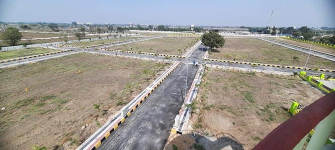
Kothur Village Telangana – Quick Overview Table
| Detail | Information |
| Location | Kothur Mandal, Ranga Reddy District, Telangana |
| Pin Code | 509228 (Kothur Mandal HQ); 501359 (Kandukur area Kothur); 500113 (Kandukur Mandal) |
| District | Ranga Reddy (reorganised from Mahbubnagar in Telangana Districts re-organisation) |
| Division | Hyderabad Metropolitan Region |
| State | Telangana |
| Altitude | Approximately 581–582 metres above sea level |
| Distance from Hyderabad | Approximately 40–51 km |
| Distance from RGI Airport | Approximately 18–25 km via NH-44 |
| Distance from Outer Ring Road | Approximately 15 minutes / 20–25 km |
| Distance from Shamshabad | Approximately 17 km |
| Assembly Constituency | Shadnagar (main Kothur town); Maheshwaram (Kandukur Mandal area) |
| Lok Sabha Constituency | Mahabubnagar / Chelvella |
| Primary Highway | NH-44 (Hyderabad-Bangalore Highway) directly through Kothur |
| Nearest Railway Stations | HBL Nagar; Kottur Railway Station; Mahabubnagar Railway Station |
| MMTS Connectivity | Yes — MMTS rail service accessible in the broader corridor |
| Key Industrial Presence | Natco Pharma; Procter and Gamble; Johnson and Johnson; Amazon Warehouse; Asian Paints; ALP Aeroflex India; Oracle Polymer Industries |
| Key Institutions | L V Prasad Eye Hospital (Kothur); Sunshine High School; Meridian High School; Symbiosis University (nearby) |
| Key Tourism | Statue of Equality – Sri Ramanujacharya (~7.9–11 km); Escape Water Park (~19.5 km); Chinna Jeeyar Swamy Ashramam (~7.6 km) |
| Property Market | Open plots; HMDA and DTCP approved layouts; affordable budget segment |
Location and Strategic Character
Kothur town sits at the intersection of NH-44 and the Kothur-Mahabubnagar Road — a position that makes it a natural logistics and residential node in the Hyderabad metropolitan southern corridor. The town serves as the mandal headquarters for Kothur Mandal, which was reorganised from the old Mahbubnagar District into Ranga Reddy District as part of Telangana’s district restructuring, reflecting the town’s administrative significance.
The broader area around Kothur on the NH-44 corridor is one of the most industrially active zones in the Hyderabad metropolitan region. Natco Pharma — one of India’s significant pharmaceutical companies — has a major facility on the Kothur to Jahangir Pir Dargah Road off NH-44. L V Prasad Eye Institute operates a notable facility in this area. Procter and Gamble, Johnson and Johnson, and an Amazon warehouse are all located on NH-44 routes branching near Kothur. Asian Paints has a warehouse operation nearby. This industrial concentration drives sustained residential demand from workers and managers in these facilities, giving Kothur’s plot market a structural demand base beyond pure speculative investment.
Infrastructure and Investment Context
The investment case for Kothur is built on multiple converging infrastructure factors. NH-44 direct frontage gives it national highway access to both Hyderabad and Bangalore. The Outer Ring Road at approximately 15 minutes by car connects the Kothur belt to the full Hyderabad metropolitan ring. The proposed Regional Ring Road (RRR) — a 340 km outer expressway encircling Hyderabad at 30–50 km beyond the ORR — will further improve the corridor’s regional connectivity when completed. MMTS connectivity in the broader belt provides rail access alongside the Kottur Railway Station on the Hyderabad-Mahabubnagar mainline.
The real estate market is primarily plots and villa-plot projects — HMDA-approved layouts, DTCP-approved layouts, and gated community ventures offering plots from 372 sq yards upward. Prices vary significantly by specific location, frontage, and proximity to NH-44.
Key Landmarks and Nearby Places
Statue of Equality (~7.9–11 km) — The 216-foot golden statue of Sri Ramanujacharya at Chinna Jeeyar Swamy Ashramam, inaugurated by Prime Minister Modi in February 2022. This is one of the world’s tallest statues of a sitting figure and has become a major pilgrim and tourist destination for the entire southern Hyderabad belt.
Escape Water Park (~19.5 km) — A popular water park accessible from Kothur, serving family recreation needs for the southern corridor.
Chinna Jeeyar Swamy Ashramam (~7.6 km) — The spiritual campus that includes the Statue of Equality, drawing regular pilgrim traffic from Hyderabad and beyond.
L V Prasad Eye Institute (Kothur) — A noted facility of the L V Prasad Eye Institute — one of India’s premier eye care institutions — providing specialist healthcare in the immediate Kothur area.
Natco Pharma — A major pharmaceutical manufacturing facility, one of Kothur’s most significant industrial employers.
5 FAQs About Kothur Village Telangana
Q1. What is Kothur village Telangana known for?
Kothur is a town and mandal headquarters in Ranga Reddy District, Telangana, situated directly on NH-44 (Hyderabad-Bangalore Highway) approximately 40 km from Hyderabad and 18–25 km from RGI Airport. Known for its industrial cluster (Natco Pharma, P&G, J&J, Amazon), HMDA-approved residential plot market, and proximity to the Statue of Equality (~7.9 km).
Q2. How far is Kothur from Hyderabad and the airport?
Approximately 40–51 km from Hyderabad city centre. Approximately 18–25 km from Rajiv Gandhi International Airport (Shamshabad) via NH-44. The Outer Ring Road is approximately 15 minutes by road.
Q3. What is the pin code of Kothur Telangana?
509228 for the Kothur Mandal headquarters. The Kandukur Mandal area of Kothur carries 501359. Assembly constituency: Shadnagar (main Kothur town); Maheshwaram for Kandukur Mandal areas. Lok Sabha: Mahabubnagar / Chelvella constituencies.
Q4. Why is Kothur considered a good real estate investment near Hyderabad?
NH-44 direct access, 15-minute Outer Ring Road proximity, industrial cluster employment (Natco Pharma, P&G, J&J, Amazon), HMDA-approved layouts, airport proximity (~18–25 km), upcoming Regional Ring Road impact, and proximity to the Statue of Equality tourism economy combine to support sustained plot value appreciation.
Q5. What is the nearest railway station to Kothur Telangana?
HBL Nagar, Kottur Railway Station, and Mahabubnagar Railway Station are the nearest rail options on the Hyderabad-Mahabubnagar mainline. MMTS rail services are accessible in the broader corridor for daily commuter connectivity toward Hyderabad.