Khera Kalan Village Delhi – Location, History, Connectivity, Nearby Places & Complete Guide
Delhi’s northern belt — the corridor between the Haryana boundary and the capital’s edge at Narela — holds a chain of agricultural villages that the city has not yet fully absorbed. Khera Kalan, also known as Badda Khera to distinguish it from its smaller neighbour Khera Khurd (Chota Khera), is one of these: a village in the Narela Sub Division of North Delhi district, covering 7 square kilometres with a 2011 census population of 11,234 and a broader locality population of approximately 29,902. The name itself is telling — “Khera” is an old settlement designation used across north India for agricultural villages built around a central communal tank or water body, and “Kalan” (meaning large or elder, from Persian) distinguishes it as the bigger of the two Khera settlements in this belt.
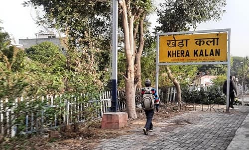
Khera Kalan Village Delhi – Quick Overview Table
| Detail | Information |
| Location | Narela Sub Division, North Delhi District, Delhi |
| Also Known As | Badda Khera |
| Pin Code | 110082 |
| District | North Delhi |
| Tehsil / Sub Division | Narela |
| Total Area | 7 km² |
| Population (2011 Census) | 11,234 (original village); 29,902 (broader locality, GeoIQ) |
| Assembly Constituency | Narela |
| Assembly MLA | Sharad Chauhan |
| Lok Sabha Constituency | North West Delhi |
| Parliament MP | Hans Raj Hans |
| Ward | Alipur Ward |
| Post Office | Khera Kalan |
| Primary National Highways | NH-9; NH-248A |
| Nearest Railway Stations | Khera Kalan Railway Station; Badli Railway Station; Holambi Kalan Railway Station |
| Metro Distance | Approximately 8 km to nearest metro station |
| Connectivity Rating | 3.8/5 (99acres residents) |
| Safety Rating | 3.8/5 |
| Key Educational Institutions | 4 schools (2 primary); Delhi Technological University (~3 km via Shahbad Daulatpur) |
| Key Neighbouring Areas | Khera Khurd; Siraspur; Naya Bans; Alipur Village; Nangli Puna; Bakoli |
| Water Source | Canal water supply (noted as strong by residents) |
History and Character
The paired naming of Khera Kalan (Badda Khera, the big one) and Khera Khurd (Chota Khera, the small one) reflects an ancient north Indian village-naming convention that paired settlements of different sizes sharing the same community identity. Both villages sit in the Narela Sub Division, both fall under the Narela assembly constituency, and both carry the same geographic and agricultural character.
The name “Khera” is used across the agricultural belt of north India — particularly in the Delhi-Haryana-UP corridor — to denote villages built around a central communal tank, where the water body formed the original community nucleus. Khera Kalan’s 7 sq km area is substantial for a north Delhi village, and its population density of 1,600 per sq km reflects a genuinely rural rather than peri-urban character, despite being within Delhi’s administrative boundaries.
Residents of Khera Kalan consistently note two things: the water supply is notably good, attributed to the canal irrigation network serving the Narela belt, and the roads become congested at peak hours (9 AM and 5–6 PM), reflecting the commuter traffic of workers who travel daily from these outer villages toward Delhi’s employment zones.
Delhi Technological University (formerly Delhi College of Engineering) is approximately 3 km away via Shahbad Daulatpur Village — a proximity that contributes a student and faculty demographic to the broader Khera Kalan belt and is frequently cited by residents as a quality-of-life advantage.
Connectivity
By Rail: Khera Kalan Railway Station is the village’s own named station — on the Delhi suburban rail network connecting toward New Delhi Railway Station. Badli Railway Station and Holambi Kalan Railway Station are additional nearby options on the Delhi Ring Railway.
By Road: NH-9 (the Delhi-Meerut corridor) and NH-248A are both accessible from the village, providing the primary arterial connections to Delhi’s road network. The broader GT Karnal Road axis connects toward Delhi’s northern urban areas.
By Metro: The nearest metro station is approximately 8 km from Khera Kalan — making it one of Delhi’s more metro-distant inhabited villages despite being within the city boundaries. DTC buses serve the primary connectivity need for daily commuters.
Key Landmarks and Nearby Places
Delhi Technological University (~3 km) — One of Delhi’s premier engineering institutions (formerly Delhi College of Engineering), located at Shahbad Daulatpur Village in the immediate vicinity, accessible within minutes.
Narela (~4–5 km) — The nearest town and administrative hub, providing commercial markets, government offices, and Narela Railway Station access.
Bawana Industrial Area (~8–10 km) — Delhi’s largest planned industrial zone, a primary employment destination for workers from the Khera Kalan-Narela belt.
Canal System — The irrigation canal network running through the Narela-Khera Kalan belt provides both agricultural water supply and the high-quality domestic water supply that residents cite as the area’s strongest practical advantage.
5 FAQs About Khera Kalan Village Delhi
Q1. What is Khera Kalan village Delhi known for?
Khera Kalan (also Badda Khera) is a North Delhi village in Narela Sub Division, covering 7 sq km with a population of approximately 29,902. Known for its strong canal-fed water supply, proximity to Delhi Technological University (~3 km), its own named railway station, and NH-9 and NH-248A road access. Pin code: 110082.
Q2. Why is Khera Kalan called “Badda Khera”?
“Badda” means big in colloquial north Indian usage, distinguishing Khera Kalan (the larger settlement) from its neighbour Khera Khurd (Chota Khera — the smaller one). Both villages share the Narela constituency and similar agricultural character, with “Kalan” (from Persian, meaning elder/larger) and “Badda” used interchangeably by locals.
Q3. Which is the nearest metro station to Khera Kalan village Delhi?
Approximately 8 km to the nearest metro station. DTC buses and the Khera Kalan Railway Station (Delhi suburban rail) are the primary transit options for daily commuters.
Q4. What is the pin code of Khera Kalan village Delhi?
110082. Post office: Khera Kalan. Assembly constituency: Narela (MLA: Sharad Chauhan). Lok Sabha: North West Delhi (MP: Hans Raj Hans).
Q5. Is Khera Kalan a good place to live in Delhi?
For families who value open space, good canal-fed water supply, and affordable housing near Delhi Technological University, with safety and connectivity both rated 3.8/5 by residents, Khera Kalan offers a practical northern Delhi village option. The metro distance of approximately 8 km is the primary commute challenge for those working in metro-accessible employment zones.